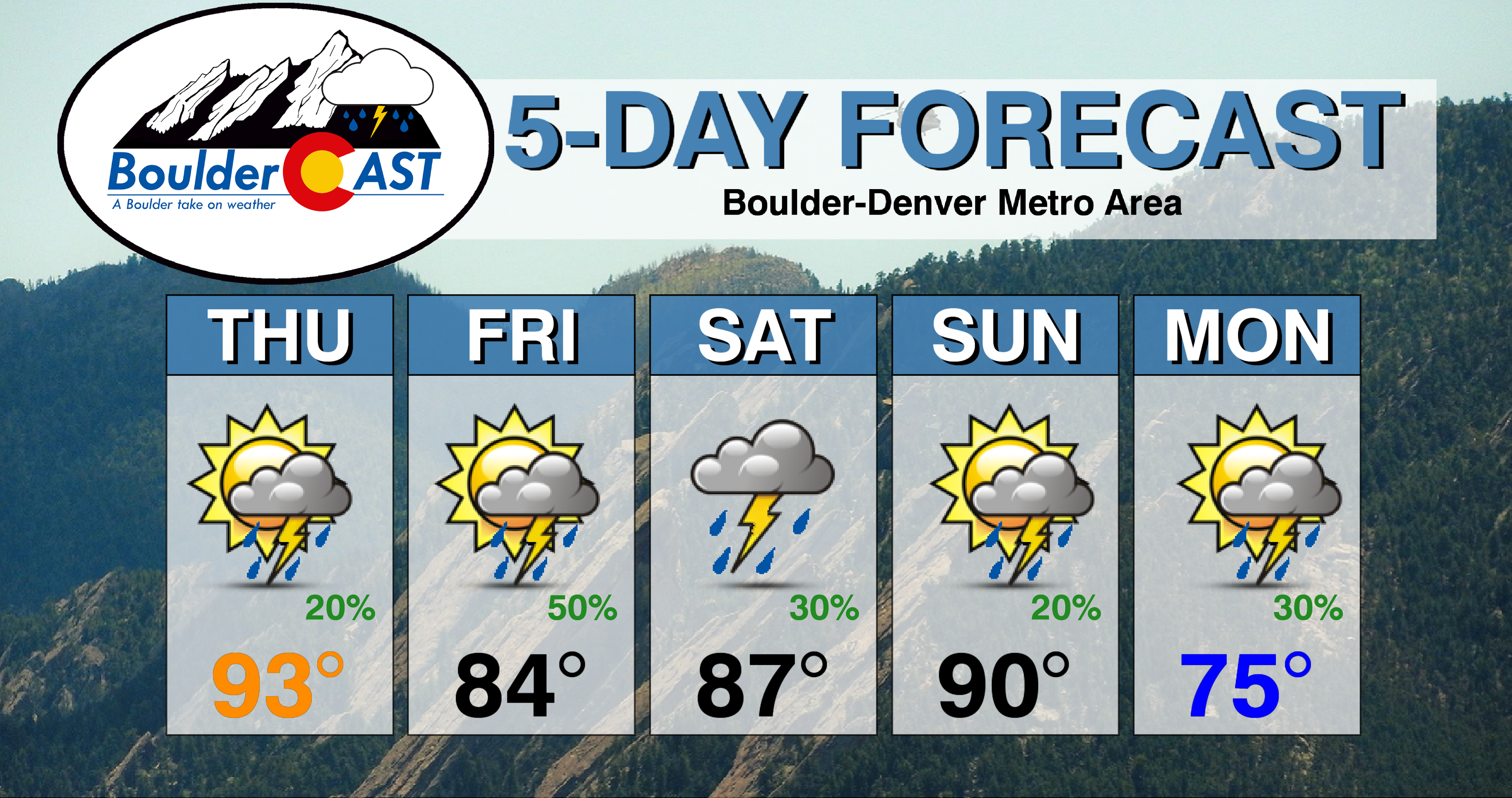
⦁❶⦁ One last hot day is expected before a cold front arrives tonight
⦁❷⦁ Widely scattered thunderstorms develop this afternoon, highs in the low to middle 90’s
⦁❸⦁ A better chance of rain tomorrow with cooler temperatures in the 80’s
⦁❹⦁ Watching a more significant cooldown early next week. Could we see highs in the 60’s?
Remember, our daily forecasts are Premium content. Periodically, we open this forecast up to all of our readers. Today is one of those days so please do enjoy!
Sign up today to get the best BoulderCAST experience, including these daily forecasts every morning, complete 6-day skiing and hiking forecasts, access of all our Front Range specific weather models, additional storm updates and much more!
Detailed Forecast Discussion
Some areas saw beneficial rainfall yesterday, though amounts were on the light side in many places. Boulder reported just 0.01″, while DIA managed 0.15″
Persistence is the story today as we will see one more 90-degree day with widely scattered showers and thunderstorms developing late this afternoon into the evening.
Today’s 500 mb map below shows all the large-scale features in-play on this Thursday:
- A weakening Hurricane Laura will move inland and eastward
- High pressure, though weaker, sits to our south in New Mexico
- Southwesterly flow the west of the ridge will continue to pump thick smoke into the central and northern Rockies. Overall, though, it looks like the worst stretch of air quality is behind us now. That is, unless a bunch of new fires develop.
- A weak trough of low pressure is along the Pacific Coast. This will weaken and largely not reach our area.
- A cold front is dropping southward out of Canada this morning and will set the stage for an active severe weather day in Wyoming and South Dakota. This front will arrive to the Front Range after midnight tonight.
The chance of rain is slightly lower than yesterday, but we still expect widely scattered coverage of storms later today, around 20% or so. The best chance of storms will be from late afternoon until sunset. Look for highs in the low to middle 90’s again, very similar to yesterday.
Behind the front, tomorrow will be a markedly cooler and wetter affair as cool moist upslope ensues. Highs will be in the 80’s, likely lower to middle 80’s, with scattered to widespread afternoon and evening thunderstorms. The Storm Prediction Center currently does not include the Denver Metro area at risk for marginally severe thunderstorms on Friday. However, given the set-up of moist upslope under-cutting southwest flow aloft and the nearby front, it is something to watch. The main threat would be hail up to 1″ in diameter. We will see if they make this adjustment to their outlook. Either way, our storm chance will be higher tomorrow around 50%.
The weekend will see highs remain in the upper 80’s to lower 90’s with slight chances for storms each day. The real cool-down arrives next week with a potent trough dropping out of Canada. We’re still seeing sizable differences between the GFS and European models with regards to where to coolest air will infiltrate. The GFS brings it directly into the Front Range with highs on Monday possibly not getting out of the 60’s (see ensemble temperature forecast below). This would definitely be our coldest day since mid-June should this verify! Have you ever been this excited for the color blue?! The Euro model drops the coolest air further west into the Great Basin, with its arrival delayed to the Front Range and weaker cooling overall.
Either way, the heat wave’s days are numbered, beginning with the weak cold front tonight and then with whatever transpires early next week as a more significant front targets our area. Here’s a look a the rainy and cooler next five days:
Finally, Hurricane Laura made landfall in the wee-morning hours local time last night in southwestern Louisiana as a Category 4 hurricane. The timing and rapid intensification just before landfall couldn’t have been more unfortunate. We’ll have to wait and see what type of devastating impacts have been felt as the day wears on. The infrared/visible combo satellite animation below from GOES-East shows Laura morphing from a disorganized mess to a Category 4 monster hurricane in only about 24 hours!
Remember, our daily forecasts are Premium content. Periodically, we open this forecast up to all of our readers. Today is one of those days so please do enjoy!
Sign up today to get the best BoulderCAST experience, including these daily forecasts every morning, complete 6-day skiing and hiking forecasts, access of all our Front Range specific weather models, additional storm updates and much more!


You must be logged in to post a comment.